liste

Bonjour et bienvenue dans mon site ! Willkommen auf meiner Seite! welcome in my homepage! http://assistance-en-sig.blogspot.com/ SIG ; Bases de données ; Géomatique; Python; ArcGIS; QGIS;

recherche

Showing posts with label arcgis online. Show all posts

Friday, May 24, 2013

ENVI Geoservices and ArcGIS® Online – A New Paradigm for Image Analytics

The development and release of ArcGIS® Online by Esri® ushered in a new era of GIS access and availability. ArcGIS Online allows organizations and individuals to manage and display their map data on the internet via an easy-to-use interface. This has been useful for GIS professionals who have been overloaded with small requests for geographic information by allowing their users to self-serve data and maps that have been developed and published by the GIS analyst. It also allows users in the field to display ground truth information that may be collected as a series of GPS points or geographic notes. According to Esri, “In addition, non-GIS professionals, such as knowledge workers who have a need for GIS, now have a way to quickly create maps from the unstructured information they work with in spreadsheets and text files and share these maps with others who can access them on any device. This type of on-demand and self-serve mapping frees up GIS professionals from having to respond to constant requests for maps and instead concentrate on making and publishing authoritative information products.” (Esri, June, 2012)
Along with map and display capabilities, ArcGIS Online comes equipped with the ability to conduct geo-processing tasks, or geoservices. Esri currently provides geocoding and network analysis geoservices, among others. Users with an ArcGIS for Server instance can also publish their own geoservices and models from the Esri software suite and consume them via ArcGIS Online. This means that customized workflows can be distributed via ArcGIS Online for consumption by non-technical users in the field. These services can be also be integrated into custom interfaces developed using the ArcGIS Web Mapping API’sor the ArcGIS Mobile Runtime SDK.
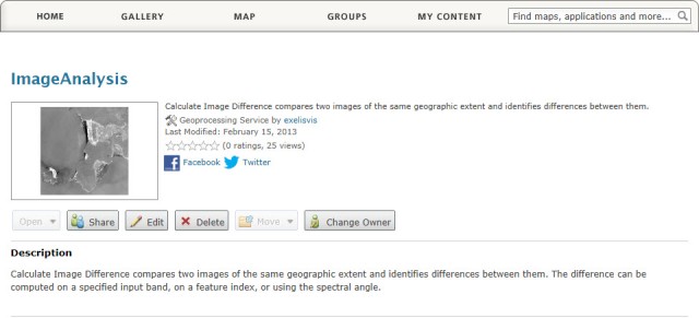
An ENVI Geoservice in ArcGIS Online
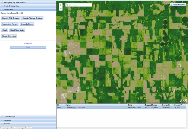
An ENVI Change Detection Geoservice in ArcGIS Online
Exelis Visual Information Solutions has worked very closely with Esri for years to develop interoperable solutions to leverage advanced image analytics from ENVI from within the ArcGIS ecosystem. Along with both desktop and server side interoperability, ENVI is now able to take advantage of the ArcGIS Online platform to expose ENVI geoservices in the cloud. Implemented using the ENVI Services Engine and the ArcGIS API for JavaScript, the app queries and consumes Landsat image services to run a number of different analysis tasks. Results are delivered back to the thin client as a visual representation, with links to download the processed datasets available if needed. Not only can this type of implementation run analysis and deliver results on remote data, the time-aware nature of the Landsat Image Service allows for time aware analysis to be conducted such as change detection, or in this case, NDVI analysis over time.
Displaying an NDVI Result from an Image Service in a Thin Client
This example of ENVI image analysis being run on image service data from the ArcGIS online environment is a snapshot of the future. In the same way that the storing and viewing of map products has migrated to the internet, so too will the analysis of large data be executed on large servers in remote locations and consumed via thin clients and mobile apps. What do you think? Are thin clients such as ArcGIS Online that consuming remote data and analysis functionality the future of GIS? Do you see a need in your organization for web-deployed analytics?
Read more

Wednesday, May 8, 2013

ArcGIS Online Download Gratuito de Imagens de Satélite das Últimas 4 Décadas


Quero, com grande prazer, documentar e divulgar uma excelente iniciativa que a empresa ESRI, criadora dos softwares proprietários da família ArcGIS, tomou este ano ao disponibilizar, de forma gratuita, imagens do satélite Landsat dos últimos 40 anos.
Isso mesmo! Imagens de satélite, gratuitas, das últimas quatro décadas! :D
A novidade permite o acesso a um patrimônio de décadas de imagens geradas pela NASA e pelo Departamento do Interior Americano (DOI). Como já citado, o acesso aos dados é gratuito através do site ArcGIS Online.
Entre outras coisas, este projeto permitirá expandir a capacidade de monitorar mudanças na paisagem ao redor do mundo. As imagens Landsat têm resolução espacial de 30 (trinta) metros e, portanto, podem ser aplicadas no estudo das mudanças climáticas, meio ambiente, ocupação de território, alterações na vegetação, só para citar alguns exemplos. (Recomendo que leia: Desmistificando o Sensoriamento Remoto)
A ESRI desenvolveu uma página interativa que utiliza os produtos de imagem Landsat para fornecer um ponto de partida para entender as mudanças na Terra ao longo dos anos.
Recebi esta notícia através do excelente portal Geo.NET (recomendo a visita e cadastro), que publicou uma notíciasobre este assunto.

Une nouvelle version pour ArcGIS Online

Une nouvelle version pour ArcGIS Online


Tous les utilisateurs d'ArcGIS connaissent et utilisent les services web de fond de carte (Basemaps) ou les services web fonctionnels (Géocodage, Calcul d'itinéraire, ...) d'ArcGIS Online. Régulièrement, cette plateforme ArcGIS Online s'enrichie en termes de contenus, arcOrama s'en fait généralement l'écho. Des annonces importantes sont attendues dans un futur proche, j'y reviendrai plus tard. ArcGIS Online c'est également une plateforme permettant à tous les utilisateurs ArcGIS de partager des ressources ArcGIS (services ArcGIS Server, Map Packages, Layer Packages, MXD, PDF,…) en définissant des règles d'accès à ces ressources. ArcGIS Online et son portail d'accès (ArcGIS.com) évolue donc aussi régulièrement en termes de fonctionnalités.

Depuis hier, une nouvelle version d'ArcGIS.com à été mise en ligne avec plusieurs avancées fonctionnelles intéressantes et une ouverture notable vers des formats non-Esri. J'en dresse une liste rapide dans cet article.


Support du format KML

Les flux KML sont désormais utilisables en tant que source de données lors de la conception de vos Web Map avec le Viewer d'ArcGIS.com. L'ajout d'entités comme les Placemarks, les Network Links, les Ground overlays et les Folders sont pris en charge. Vous pouvez également référencer et partager des flux ou des fichiers KML sur ArcGIS Online comme vous le faites déjà pour toutes vos ressources ArcGIS à l'aide de l'onglet "My Content". 


Ajout d'un flux KML (Tracé du Tour de France 2011) dans une Web Map


Support des services OGC (WMS)

Les services WMS sont désormais utilisables en tant que source de données lors de la conception de vos Web Map avec le Viewer d'ArcGIS.com. Vous pourrez également référencer et partager ces services sur ArcGIS Online comme vous le faites déjà pour toutes vos ressources ArcGIS à l'aide de l'onglet "My Content". Lors de l'ajout de services WMS vous aurez la possibilité de sélectionner et de renommer les couches que contient le service afi de les indexer et de les retrouver de manière plus efficace.


Ajout d'un service WMS issu de Gest'Eau dans une Web Map


Import d'entités dans la carte à partir de fichiers texte

Les entités décrites par une latitude et une longitude dans un fichier texte (.csv ou .txt) ou dans des fichiers d'échanges GPS (.gpx) peuvent désormais être importées dans votre Web Map. Vous pouvez alors configurer des fenêtres de Pop-Up sur ces entités et personnaliser leur rendu.


Rendu personnalisés

Lors de l'ajout de fichier .csv, .txt ou .gpx, vous pouvez personnaliser l'apparence des entités affichées sur la carte. Par exemple, vous pourrez choisir des options d'affichage comme un rendu par symboles uniques, par valeurs uniques, par dégradé de couleurs, par dégradé de symboles, …


Renommage des couches

Vous pouvez désormais renommer les couches (de premier niveau) dans la table des matières de votre carte via les propriétés de la couche.

Amélioration sur la mise à jour de données

Lors de la mise à jour de données avec le Viewer d'ArcGIS Online, vous pouvez utiliser des fonctions d'accrochage.

Gérer les contenus d'un groupe

Désormais, le propriétaire (créateur) d'un groupe d'utilisateurs peut gérer des contenus pour l'ensemble des membres du groupe. Il peut partager avec tous les membres, des contenus rendus publics par leur propriétaire. Il peut également départager des contenus qu'un membre du groupe à partager avec les autres membres si il estime que ce contenus n'est pas approprié pour ce groupe.

Une version d'ArcGIS.com pour les smartphones

Une version optimisée du site ArcGIS.com et de son Viewer intégré s'affichent maintenant automatiquement lorsque celui-ci est accédé à partir d'iPhone, d'Android 2.2 ou d'un Blackberry Torch. Complètement adapté à un usage sur smartphone, le site propose les mêmes fonctions de partage, de gestion, de recherche et de consultation de contenus ArcGIS Online.


A suivre...

Les évolutions d'ArcGIS Online vont être nombreuses dans les prochains mois. Esri fera d'ailleurs des annonces lors de la conférence de San Diego, la semaine prochaine. Nous reviendrons donc sur le sujet.

Wednesday, March 27, 2013

arcOrama: 100 lignes ou moins

Esri lance aujourd'hui même le concours 100 lignes ou moins. Ce concours est destiné aux développeurs Javascript. Son objet est de développer l'application la plus cool en moins de 100 lignes et utilisant l'API Javascript pour ArcGIS.

Les prix sont :
- 1er prix : un abonnement d'un an à ArcGIS Online et une entrée au Developer Summit 2014 Esri
- 2ème prix : une entrée au Developer Summit 2014 Esri
- 3ème 100$ de bon d'achat Esri Press

Le vainqueur sera proclamé lors du Developer Summit 2013 fin mars à Palm Springs, Californie.

Rendez-vous sur Github, forkez et clonez le repo et c'est parti !

Sunday, February 24, 2013

What is ArcGIS Online?


ArcGIS Online is a complete, cloud-based, collaborative content management system that lets organizations manage their geographic information in a secure and configurable environment. The platform provides an on-demand infrastructure for creating web maps, web-enabling your data, sharing your map, data, and applications, and managing content and multiple users from your organization. It includes basemaps, data for your maps, applications, configurable templates, and GIS tools and APIs for developers. Organizations purchase a subscription which allows them to configure and manage their own ArcGIS Online site and set of resources. A subscription includes organizational accounts for members of the organization. Personal accounts are available for individuals who want to access content shared by Esri and GIS users and create, store, and share maps, apps, and data.

What can you do with ArcGIS Online?

A subscription to ArcGIS Online allows organizations to manage their geospatial content in a secure environment, publish maps and data in Esri's secure cloud, configure their own ArcGIS Online website, and create maps and apps from APIs, templates, and tools. It also gives them resources to share and collaborate with its members and beyond the organization. Organizations can share their geospatial content and provide access to critical information while staying in control of their data.

Manage your organization's geospatial content in a secure environment

Through a subscription, you get flexible data storage capabilities and administrative controls for managing user roles and access levels. Administrators of the subscription can invite specific users or groups of users with already established logins used in the organization and monitor usage through an intuitive dashboard. You can share content through groups with members of your organization, keep it private, or make it public. You stay in control of your data, lower your infrastructure costs, and empower your users and customers with easy-to-use, web-enabled content.

Publish maps and data as hosted services in Esri's secure cloud

Organizations can publish their maps and data as web services on ArcGIS Online. Esri takes care of hosting the services and scaling to meet demand. Web, desktop, and mobile applications can access the hosted services from anywhere on the Internet if the publisher chooses to allow it. The services can be published directly from ArcGIS for Desktop or the ArcGIS.com website.

Source arcgis.com

Saturday, January 12, 2013

Version 10.1.1 of ArcGIS Runtime SDK for iOS now available!


At the start of this new year, we’re happy to announce that a new version of ArcGIS Runtime SDK for iOS is now available. . This release adds support for commonly requested functionality such as advanced military symbology, secure communication using PKI client certificates, simulating location updates, sorting and grouping query results, and much more. You can download the SDK here.

Those of you closely following the SDK releases will notice that the version number of this release (10.1.1) is significantly different from the version numbers we’ve been using  in the past. This was done to synchronize the version numbers between various Runtime SDKs (Android, Java SE, WPF, Windows Phone) and the overall ArcGIS system.  This synchronization not only reflects a common path of evolution going forward for each of the SDKs, but also a commonality in terms of their functionality and architecture.
Speaking of architecture, we’ve had to make significant changes to the map control and display subsystem in order to take advantage of hardware acceleration and pave the way for functionality that just couldn’t have been possible earlier. As much as we’ve tried to shield you from these internal changes, some of them have bubbled up to the public API. These changes are listed in the Migration section of the What’s New document. We encourage you to refer to this document as you migrate your applications. As always, we will be monitoring the user forum for your feedback and to offer help along the way.

Thursday, January 10, 2013

ArcGIS Online + ArcGIS for Server Map Services


A portion of this fall’s Transform Your Organization seminar series described the steps to add ArcGIS for Server map services to ArcGIS Online. It was an “Aha!” moment for many attendees who were curious about the relationship between ArcGIS Online and ArcGIS for Server. Those attendees left the Seminar with clarity for what this relationship offers, specifically as it relates to web maps.
What if you did not attend the Seminar? You might be wondering how ArcGIS for Server and ArcGIS Online complement one another. To answer this question, let’s walk through a use case starting with what you know – the map service:
These are ArcGIS for Server map services published from your server. In this example, they represent voting districts, property boundaries, parks, service requests, and building permits. Instead of using these map services to build an application with Flex, JavaScript, Silverlight, or a mobile SDK (e.g. Apple iOS), we are going to register these services with ArcGIS Online.
Adding these services to ArcGIS Online makes them available as live, authoritative content for building web maps – the powerful new medium GIS pros (and non-GIS pros) are using to reach a new audience with online maps.

Thanks for making donation by clicking some ads

The steps to add ArcGIS Server services can be found in the Adding items from the web help topic. Note Step 4 – Choose the type of item:  ArcGIS Server web service
Imagine if your whole library of authoritative content were available to the ArcGIS Online users in your organization. It would only take a few minutes to build a web map for a city administrator we’ll name “Susan” showing voting districts and the status of building permits throughout the city. Susan could explore this web map from her desktop browser, or if security rules allow, she could study the web map from her smartphone while she’s out exploring the community.
ArcGIS for Server map services, like the ones in Susan’s web map, might have been less visible in the past. Now, by adding those map services to ArcGIS Online, they can be discovered and accessed by diverse groups of users in a very elegant, thought-provoking kind of way. I’ll bet Susan and her colleagues never imagined having such valuable and timely information on their smartphone (or tablet) as an interactive, GPS-enabled map!
ArcGIS Online offers many great ways to add content to a web map, each having its unique advantages. With these options, it remains true that a good map is delivered on time, with relevant and up-to-date information. One advantage of ArcGIS for Server map services is that they always represent the live information as its being managed on your server(s). This is why map services are an excellent way to empower ArcGIS Online users with the rich and up-to-date content they crave – and sometimes require – for great web maps.
Read more  www.esri.com


Thanks for making donation by clicking some ads