Citysurf is a server based 3D GIS software, developed by PiriReis. Citysurf is a new model for serving maps and interacting with the end user and has been created to model and serve raster data at high speed and low bandwidth. Databases such as high resolution satellite images and aerial images are combined with digital terrain models and vector-based geographical information. Citysurf can serve data over local networks or the internet. Each end user can manage and analyse geographical data through the Citysurf Globe interface with advanced authorization system incorporated in CitySurf.


CitySurf Globe is a family of Geography 2.0 Geographical Information System software, developed by PiriReis Bilişim Teknolojileri, known as a new model in mapping servers and interaction with the end user.
CitySurf Globe family models raster data, such as high resolution satellite images and aerial images, under high speeds using digital terrain model and vector geographical information systems and accordingly serves these via internet or local nets. Prepares geographical analyses and arranges the geographical data thanks to its interaction with the end user.
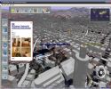
CitySurf Globe has an OpenGL-based viewer, which connects to the servers for streaming of content, elevation, satellite and/or airphoto imagery, roads, 3D buildings, points of interest, etc. This is similar to Google Earth, Microsoft Virtual Earth, and ArcGIS concepts.
It is able to:
- Fast transfer and secured data due to special data storage structure
- On the fly projection conversion which allows the usage of all sorts of data in different coordinate systems
- Perfect adaptation to different authorization needs of your company/organization with flexible authorization models for different user groups
- Creation of geographical objects (Point, Line, Polygon)
- Raster layer support in client and server (tiff, jpeg, png, KML 2.0)
- With the help of “Search scenario editor” various search windows could be formed and the results could be displayed according to the authorization level of the client
- Spatial filtering in search window
- Upload of geographic and spatial data by both Server and Client
- RDBMS supports Oracle SDO, PostGIS
- CitySurf Globe Client allows the user to prepare Thematic Maps (layers and columns which are going to be mapped thematically are defined by the server)
- Virtual trip on the image and movie recording
- Local GPS support
- Real time visibility and 3D profile analysis
- Data added by the Client can be sent via email to other users
- GPS tracking
- Reverse geocoding
- GeoRSS support
- GeoDynamic layer support
I can not install this program, any sugest ?
ReplyDelete