| AutoCAD® DXF/DWG to ESRI Shapefile converter New release - CAD2Shape 6.0Supports all AutoCAD versions up to AutoCAD 2014 CAD2Shape 6.0 converts AutoCAD DXF/DWG drawing files to ESRI shapefile format files (ArcView, ArcGIS, ArcMap etc.)
Features  Stand-alone CAD to Shapefile conversion. Translates all AutoCAD DXF and DWG versions up to and including AutoCAD 2014 New Optional translation to 2D or 3D shapefiles. Attach Z value as 'Elevation' data. Text to 'Labels Theme'. Text to exploded polyline option. - allows direct translation of CAD Text to visible text in ArcGIS/ArcMap/ArcView. The resultant text and placement will be visually identical to that in the originating CAD drawing. Attributes translation. Translate holes / islands /donuts from originating CAD drawing to Polygon shapefile. see picture Extended Entity Data (Xdata) translation. Translate 3D surfaces to MultiPatch shapefile types. Option to output to raw data file: e.g. CAD to XYZ, CAD to CSV, CAD to BLN New(Surfer Blanking file format). MPolygon support. New Dimensions/Leader/Tolerance support. New Additional XDATA types. New Length attribute for polylines. New Filter by Layer, Area, Color, Entity. Data suitable for import to Google Earth Pro Stand-alone CAD to Shapefile conversion. Translates all AutoCAD DXF and DWG versions up to and including AutoCAD 2014 New Optional translation to 2D or 3D shapefiles. Attach Z value as 'Elevation' data. Text to 'Labels Theme'. Text to exploded polyline option. - allows direct translation of CAD Text to visible text in ArcGIS/ArcMap/ArcView. The resultant text and placement will be visually identical to that in the originating CAD drawing. Attributes translation. Translate holes / islands /donuts from originating CAD drawing to Polygon shapefile. see picture Extended Entity Data (Xdata) translation. Translate 3D surfaces to MultiPatch shapefile types. Option to output to raw data file: e.g. CAD to XYZ, CAD to CSV, CAD to BLN New(Surfer Blanking file format). MPolygon support. New Dimensions/Leader/Tolerance support. New Additional XDATA types. New Length attribute for polylines. New Filter by Layer, Area, Color, Entity. Data suitable for import to Google Earth ProOperating System: Windows 2000/2003/2008/Citrix/XP/XP64/Vista/Vista64/Win7/Win7x64 Check it out for yourself! Application developers! Developer Component CAD2Shape DLL here. |
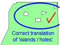
correct translation
of holes | |||||||||
 | ||||||||||
Monday, October 28, 2013
AutoCAD® DXF/DWG to ESRI Shapefile converter

Subscribe to:
Post Comments (Atom)
No comments:
Post a Comment