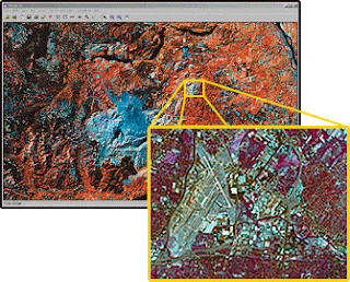
Digital image classification assigns pixels to classes. Each pixel is treated as a set of values in several spectral bands, derived from the brightness of the same area on the earth's surface. By comparing pixels to one another, and to pixels of known identity, it is possible to assemble groups of similar pixels into classes that are associated with the informational categories of interest to clients. Because these classes form regions on an image, after classification, the digital image is presented as a mosaic of uniform parcels, each identified by a color or symbol. These classes are, in theory, homogeneous-- pixels within classes are spectrally more similar to one another than they are to pixels in other classes. In practice, of course, each class will display some variation, because category exhibits natural variation. Image classification forms one of the most important tools for examination of digital images--sometimes to produce a final product, other times as one of several analytical procedures applied to derive information from an image.
Image classification requires the analyst to matchinformational classes to spectral classes. Informational classes are the categories of interest to the ultimate users of the data. Informational classes are (for example) the different kinds of forest, or the different kinds of land use that convey information to planners, managers, and scientists who will use information derived from remotely sensed data. These classes convey the information that we wish to derive from the data--they are the object of our analysis. Unfortunately, remotely sensed images do not directly convey informational classes-- we can derive them only indirectly, using the brightnesses that compose each image. For example, the image cannot directly show geological units, but rather only the differences in topography, vegetation, soil color, shadow, and other factors that lead the analyst to conclude that certain geological conditions exist in specific areas.
In contrast, Spectral classes are groups of pixels that are uniform with respect to brightnesses in their several spectral channels. The analyst defines spectral classes within remotely sensed data; then must define links between spectral classes on the image and informational classes that are of interest to the client. In this manner, image classification proceeds by matching spectral categories to informational categories. If the match can be made with confidence, then the information is likely to be reliable. If spectral and informational categories do not correspond, then the image is unlikely to be a useful source for that particular application.
Informational classes are typically composed of numerous spectral subclasses--spectrally distinct groups of pixels that together may be assembled to form an informational class. In digital classification, we must often treat spectral subclasses as distinct units during classification, but then display several spectral classes under a single symbol for the final image or map to be used by planners or administrators (who are, after all, interested only in the informational categories, not the intermediate steps required to generate them).
Overview of Process of Supervised Image Classification
- select prospective training areas (training data polygons)
- evaluate the training areas on the basis of
- visible features
- normalilty
- separability
- partitioning
- make decisions on which training areas to use
- classify the scene
- evaluate the accuracy using an error (contingency) matrix
Unsupervised classification can be defined as the identification of natural groups, or structures, within multispectral data. The notion of the existence of natural, inherent groupings of spectral values within a scene may not be intuitively obvious, but it can be demonstrated that remotely sensed images are usually composed of spectral classes that internally are reasonably uniform in respect to brightnesses in several spectral channels. Unsupervised classification is the definition, identification, labeling, and mapping of these natural classes.
read more:

No comments:
Post a Comment