WinSQL is universal database management tool that can be used with any relational database to perform administrative tasks such asimporting/exporting data, generating test data, reverse engineering an existing database, comparing schema and data between databases or simply running SQL queries. On one hand WinSQL provides advanced user powerful tools to help them manage their database, on the other hand several wizards in WinSQL help novice users to view and modify existing data on any relational database. In short, WinSQL is a must-have tool for any programmer or DBA who work with a variety of databases in their day-to-day life.
Saturday, March 30, 2013
spatial data
Also known as geospatial data or geographic information it is the data or information that identifies the geographic location of features and boundaries on Earth, such as natural or constructed features, oceans, and more. Spatial data is usually stored as coordinates and topology, and is data that can be mapped. Spatial data is often accessed, manipulated or analyzed through Geographic Information Systems.
GIS Spatial Data Types
In GIS, there are 2 basic spatial data types representing the real world:
Raster and Vector
The Real World
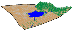
In this example, our landscape consists of
- rolling hills
- grassland
- lake
- rivers
- forest stands
- marsh
Raster Data
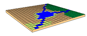
In the raster data model, land cover is represented as:
- single square cells
Each cell will have a value corresponding to its land cover type.
Raster data are good at:
- representing continuous data (e.g., slope, elevation, chemical concentrations)
- representing multiple feature types (e.g., points, lines, and polygons) as single feature types (cells)
- rapid computations ("map algebra") in which raster layers are treated as elements in mathematical expressions
- analysis of multi-layer or multivariate data (e.g., satellite image processing and analysis)
- hogging disk space
Vector Data
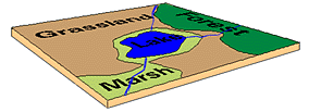
In the vector data model, features on the earth are represented as
- points
- lines / routes
- polygons / regions
- TINs (triangulated irregular networks)
Vector data are good at
- accurately representing true shape and size
- representing non-continuous data (e.g., rivers, political boundaries, road lines, mountain peaks)
- creating aesthetically pleasing maps
- conserving disk space
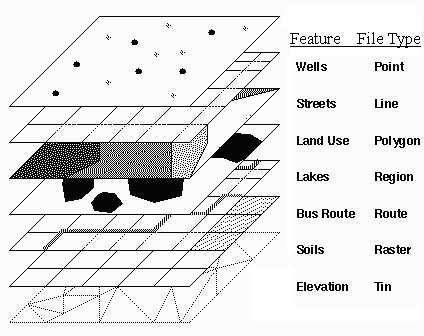
Different types of data are
stored in different
file formats.
images © ESRI
Trial Software Help and Resources: ArcGIS Desktop 10 Trial Software
All the help and resources you need to get up and running with your trial software are provided here through videos, instructions, and commonly asked questions.

Before You Start
- Check our system requirements to make sure your computer has the hardware and software required for the trial.
- The trial software cannot be installed on a computer that has a previous version of ArcGIS Desktop or ArcGIS Server installed. It's OK if the computer has ArcGIS Explorer installed.
- The download file sizes are 3.76 Gb for ArcGIS Desktop 10 and 1.87 Gb for the optional tutorial data. Download times vary depending on your Internet connection.
Download and Extract
This video will show you how to extract the ISO file containing the trial software.
The steps are also listed in the How To section below.
How to Download and Extract
- At this point, you should have a file from a DVD or from the Internet. If you don't have the file, request the trial software.
- Install the free image (ISO) extractor program 7-Zip, then use it to extract the files.
- Go to Start > 7-Zip > File Manager. Locate and click ArcGIS Desktop.exe, then click Extract. Choose a location for the extracted files and click OK. This process can take a couple of minutes.
Installation
 This video will show you how to install and authorize the trial software.The steps are also listed in the How To section below.How to Install and Authorize
- Go to /DotNet35 folder and run setup.exe to install the Microsoft® .NET Framework 3.5 SP1. This isrequired to install ArcGIS Desktop.
- Go to the DVD or to your extracted ISO image location and run Esri.exe. This opens the Quick Start Guide.Note: The Quick Start Guide contains instructions that do not pertain to the trial edition. Please disregard the following sections: All sections on the ArcGIS License Manager 10, Authorize ArcGIS Desktop 10 Concurrent Use, Borrowing and returning licenses, and Getting Support.
- It's required that you uninstall any previous versions of ArcGIS Desktop or ArcGIS Server before running the setup. Under Uninstall Existing ArcGIS Software, click Detect Conflicts to remove previous versions.
- To the right of ArcGIS Desktop, click Setup.
- Click Next and accept the license agreement. Choose Complete and click Next. Click Next to accept all default settings, then click Finish.
Using ArcGIS
Starting ArcGIS Desktop 10ArcGIS Desktop contains two applications: ArcMap and ArcCatalog. ArcMap provides data display, query, and analysis. ArcCatalog provides data management.
To start the software, click Start > All Programs > ArcGIS > then choose ArcMap 10 or ArcCatalog 10.Resources and Tutorials- Many tutorials are found in the ArcGIS Desktop Help. To perform the exercises in the tutorials, you'll need to install the ArcGIS tutorial data.
- You'll find additional resources such as what's new, forums, blogs, samples, downloads, and knowledge-base articles on the ArcGIS Resource Center. You can also access it from from Start > All Programs > ArcGIS > ArcGIS Desktop Help menu.
- Free, one-hour recorded training seminars are also available.
Trial Period and Expiration- The trial period begins when you initiate the authorization process and Esri issues your authorization file. If you installed the software but have not authorized it, your trial period has not started. The trial period varies with the edition you have:
- Standard edition: 60 days
- Esri Press edition: 180 or 90 days (varies by book)
- Education edition: 365 days
- You can see the expiration information by using the ArcGIS Desktop Administrator. Click Start > All Programs > ArcGIS > Desktop Administrator > then click on the Availability folder.
- You cannot extend the trial period or reinstall the trial software.
Software : Esri CityEngine Advanced 2011.2 with Document

Esri CityEngine Advanced 2011.2 with Document | 1.03 GB
Esri CityEngine is a stand-alone software product that provides professional users in architecture, urban planning, entertainment, GIS and general 3D content production with a unique conceptual design and modeling solution for the efficient creation of 3D cities and buildings.
About Ersi
When Esri was founded in 1969, we realized even then that geographic information system (GIS) technology could make a difference in society. Working with others who shared this passion, we were encouraged by the vast possibilities of GIS.
Today, our confidence in GIS is built on the belief that geography matters—it connects our many cultures and societies and influences our way of life. GIS leverages geographic insight to ensure better communication and collaboration.
As you explore our Web site, you'll discover how our customers have obtained the geographic advantage by using Esri software to address social, economic, business, and environmental concerns at local, regional, national, and global scales. We hope you will be inspired to join the Esri community in using GIS to create a better world.
Features
- GIS Data Support
CityEngine supports the use of geospatial data such as Esri Shapefile, File Geodatabase (GDB), KML, and OpenStreetMap (OSM), allowing you to work with existing GIS features – like parcels, building footprints and street center lines – when constructing 3D urban landscapes.
- Industry-Standard 3D Formats
CityEngine works with many 3D formats, including Collada, Autodesk® FBX, DXF, 3DS, Wavefront OBJ, and e-on software Vue. Constructed 3D content can also be exported out to Pixar's RenderMan® RIB format and NVIDIA's mental ray MI format.
- Rule-based Modeling Core
Procedural modeling offers the ability to generate and texture detailed 3D buildings and street geometries out of 2D data. Many example rules are included with CityEngine and new custom rules can be authored using your own textures and 3D assets.
- Parametric Modeling Interface
CityEngine exposes a set of interactive controls to adjust rule parameters, allowing experimentation with model construction settingssuch as the height, roof form or age of a building. Parameter modifications will automatically invoke regeneration of the 3D model.
- Dynamic City Layouts
A toolset is provided to design and edit urban layouts with streets, blocks and parcels. Street construction or block subdivision is controlled via parametric interfaces, giving immediate visual feedback.
- Facade Wizard
Create rules from an image or textured mass model with an easy-to-use facade authoring tool. The resulting facade rules are size-independent, contain level-of-detail and can be extended.
- Map-Controlled City Modeling
Parameters of buildings and streets can be controlled globally using maps ( e.g., land use), allowing for easy city modeling and quick changes. Terrains can be imported, aligned, and exported.
- Street Networks Patterns
CityEngine offers unique street growth tools to quickly design urban layouts. Street patterns such as grid, organic or circular are available, and the topography of the terrain is taken into account.
- Reporting (BIM for Cities)
Customized rule-based reports can be generated to analyze urban designs, including the calculation of important urban propertiessuch as GFA (Gross Floor Area), FAR (Floor Area Ratio), and so on. Reports are updated automatically and instantaneously.
- Python
Streamline repetitive or process-specific tasks with the integrated Python scripting interface, such as, writing out arbitrary meta-data or instancing information for each building, import FBX cameras etc.
Download
GIS Job
An offshore survey company looking for potential candidates for the following position
1. Junior/Senior GIS Analyst
2. Must posses related certification i.e bachelor degree, diploma, post graduate etc
3. Minimum 1 year(s) experience in related skills in ArcGIS such as cartography, geodatabase, editing and COGO as well in CAD environment.
4. Experience in Oil and Gas and programming i.e .NET, JAVA will be extra advantage
5. If you think that you're suitable for above requirement, please send your CV to me ASAP to dsug.uitm@gmail.com
Datums and Map Projections: For Remote Sensing, GIS and Surveying
Datums and Map Projections: For Remote Sensing, GIS and Surveying

New methods of acquiring spatial data and the advent of geographic information systems (GIS) for handling and manipulating data mean that we no longer must rely on paper
Datums and
Newcomers to the field will welcome this treatment that, instead of detailed mathematics, uses lucid explanations and numerous examples to unravel the complexities of the subject. For more experienced readers, the book is a valuable reference that answers specific questions and imparts a better understanding of transformation operations and principles.
Download for free ArcGIS server Entreprise 10.1
Download for free ArcGIS server Entreprise 10.1
ArcGIS server Entreprise 10.1 kostenlos runterladen
Télécharger ArcGIS server Entreprise10.1 gratuitement
pour plus d'info http://assistance-en-sig.blogspot.com/
Download for free ArcGIS server Entreprise 10.1
http://assistance-en-sig.blogspot.com/2012/11/download-for-free-arcgis-server.html
download for free ArcGIS Desktop Tutorial data 10.1
Télécharger ArcGIS 10.1 gratuitement
http://assistance-en-sig.blogspot.com/2012/11/telecharger-arcgis-100-gratuitement.html
download ArcGIS Desktop 10.1 for free
Download for free ArcGIS 10.1
ArcGIS 10.1 kostenlos runterladen
Télécharger ArcGIS 10.1 gratuitement
 ftp://150.131.194.1/Special/
for more information http://assistance-en-sig.blogspot.com/
pour plus d'info http://assistance-en-sig.blogspot.com/
download for free ArcGIS Desktop Tutorial data 10.1
ArcGIS 10.1 kostenlos runterladen
Télécharger ArcGIS 10.1 gratuitement
for more information http://assistance-en-sig.blogspot.com/
pour plus d'info http://assistance-en-sig.blogspot.com/
Download for free ArcGIS server Entreprise 10.1
http://assistance-en-sig.blogspot.com/2012/11/download-for-free-arcgis-server.html
download for free ArcGIS Desktop Tutorial data 10.1
Télécharger ArcGIS 10.1 gratuitement
http://assistance-en-sig.blogspot.com/2012/11/telecharger-arcgis-100-gratuitement.html
ArcGis 10 Desktop x32 x64 crack Full Download
ArcGis 10 Desktop x32x64 crack
arcgis 10 crack for windows 7 64 bits

arcgis 10 crack for windows 7 64 bits

Télécharger gratuitement le crack pour ArcGIS 10 Desctop pour windows 7 et autres systèmes d'exploitation
Le lien est utile pour ArcGIS ArcInfo, ArcGIS ArcEditor.
ArcGIS contient toutes les composantes: ArcMap, ArcCatalog et ArcToolbox ainsi que Python.
Si vous trouvez ce lien utile merci de faire un don en cliquant sur l'un des liens publicitaires
arcgis, arcgis 10, arcgis 10.1, crack, download, free, keygen, télécharger
New: Keygen for ArcGIS 10.1 download for free
Use the links to download the crack for arcgis 10.1 for free without registration

Download
Télécharger
Runterladen
If you are satisfied please make a donation by clicking one of the ads Thanks
Si vous trouvez ce lien utile merci de faire un don en cliquant sur l'un des liens publicitaires dans le cadre
Download
Télécharger
Runterladen
If you are satisfied please make a donation by clicking one of the ads Thanks
Si vous trouvez ce lien utile merci de faire un don en cliquant sur l'un des liens publicitaires dans le cadre
Wednesday, March 27, 2013
arcOrama: 100 lignes ou moins
Esri lance aujourd'hui même le concours 100 lignes ou moins. Ce concours est destiné aux développeurs Javascript. Son objet est de développer l'application la plus cool en moins de 100 lignes et utilisant l'API Javascript pour ArcGIS.
Les prix sont :
- 1er prix : un abonnement d'un an à ArcGIS Online et une entrée au Developer Summit 2014 Esri
- 2ème prix : une entrée au Developer Summit 2014 Esri
- 3ème 100$ de bon d'achat Esri Press
Le vainqueur sera proclamé lors du Developer Summit 2013 fin mars à Palm Springs, Californie.
Rendez-vous sur Github, forkez et clonez le repo et c'est parti !
Tuesday, March 19, 2013
freelancing GIS work
If you have a freelance work in the field of GIS please contact us in order to publish it for you for free.
Thanks
Thanks
Monday, March 18, 2013
Functionality Matrix for ArcGIS 10 and Server
This matrix also includes functions for the optional ArcGIS for Desktop extensions which offer specialized tools and additional capabilities to enhance your system.
If you’re using Server, there is also a functionality matrix for ArcGIS Server: http://www.esri.com/library/brochures/pdfs/arcgis-server-functionality-matrix.pdf.
source esri dot com
arcgis 10 crack for windows 8 64 bits rapidshare download
Microsoft has recently released Windows 8 and we have just released ArcGIS 10.1 Service Pack 1. I’m pleased to announce that Windows 8 and Windows Server 2012 are now supported operating systems for ArcGIS 10.1 SP1.
download here
source rapidshare dot com
download here
source rapidshare dot com
JOB: Junior/Intermediate GIS Analyst - Vancouver or Nanaimo, British Columbia
Company: Golder Associates Ltd.
Position: Junior/Intermediate GIS Analyst (2013-8833)
Location: Vancouver or Nanaimo, British Columbia
Salary:
Contact Name: Human Resources
Job Description
????As a global, employee-owned organisation with over 50 years of experience, Golder Associates is driven by our purpose to engineer earth’s development while preserving earth’s integrity. From more than 180 offices worldwide, our over 8000 employees deliver solutions that help our clients achieve their sustainable development goals by providing a wide range of independent consulting, design and construction services in our specialist areas of earth, environment and energy.
For more information, visit golder.com.
Job Responsibilities:
We are building our Geospatial Solutions and Visualization service area and have an immediate vacancy for a Junior/Intermediate GIS Analyst with a passion for GIS and an interest in supporting sustainability, planning, environmental assessment and design. We strive to provide elegant solutions for a diverse array of topic areas such as climate and energy strategies, official community plans, and environmental impact assessments. As a GIS analyst, you would be working with other GIS team members to create a wide array of mapping and analysis products ranging from environmental network analysis to land use plans and 3D visualization in support of both our planning and design teams as well as for other Golder offices, which are located throughout the world. If you see GIS as a tool that can make data speak through engaging imagery, we are interested in speaking with you. The work is highly varied, innovative and fast-paced.
This position is available in either the Vancouver or Nanaimo offices, providing support for staff located in both offices as well as other Golder offices as needed.
The Vancouver office is located in historic Gastown in a renovated heritage building. Numerous amenities are within easy walking distance. Vancouver offers year round recreational and cultural activities. The Nanaimo office is located between the City Centre and the historic Old City Quarter. Nanaimo is centrally located with access to the many recreational and cultural activities on Vancouver Island as well as Vancouver. You will be part of a talented, welcoming, motivated, team-oriented group of GIS professionals with a passion for sustainability and strong sense of community.
Job Qualifications
?Job Requirements:
The ideal candidate must have at least 3 years’ experience working with Geographic Information Systems, be highly creative and numerically literate, have strong organizational and problem-solving skills, be focused on providing high quality service and products, and have a track record of completing projects and tasks on time and with professionalism. An education or experience in urban planning and design, environmental or transportation planning or related disciplines is preferred. As you will be consistently working with clients and staff at various levels within our company, strong interpersonal skills are highly valued. Responsibilities include the following:
- Diploma and/or Undergraduate degree in related discipline, or comparable experience;
- 3 to 5 years of experience with geospatial technology is required;
- Experience using ESRI products and data formats, in particular ArcGIS version 10 and its associated extensions particularly spatial analyst, network analyst and 3D Analyst;
- Working knowledge of Python, and any other scripting languages used in GIS;
- Experience using ESRI ModelBuilder is required;
- Experience with problem-solving, statistics, and raster processing;
- Familiarity with a variety of spatial data types, formats, projections and datums;
- Understanding of quality control measures appropriate for information management and cartography;
- Strong organizational skills;
- Project and client focused with regard to timelines, team engagement, communication, and schedules; and
- Strong written and verbal communication skills.
Other Information
Application:
Interested applicants are encouraged to apply on-line at www.golder.com in the Career/Canada section. No phone calls please, only those candidates whose background closely matches the opportunity will be contacted for an interview. Competition will close when a suitable candidate is found. Thank you for your interest in Golder Associates Ltd.
Golder Associates Ltd.
500-4260 Still Creek Drive
Burnaby, BC
V5C 6C6
Homepage - www.golder.com
E-Mail - Please apply online @ www.golder.com
Ingénieur(e) d’études en géomatique pour la restauration des milieux aquatiques
BAP/ discipline : A/ Science du vivant (SV)
Emploi-type : Ingénieur(e) en techniques d’étude des milieux naturels et ruraux
CONCOURS ouvert aux candidats possédant au minimum un diplôme de niveau II (licence…)
Concours n°IE-2013-1-HYAX
NB: dans certains cas et sous certaines conditions, les candidats peuvent demander la reconnaissance de l’équivalence des diplômes qui n’apparaissent pas sur la liste des diplômes exigés aux concours, des diplômes délivrés ou reconnus par un des Etats membres de l’Union européen ou un des Etats parties à l’accord sur l’Espace économique européen, ou de la qualification professionnelle acquise.
Description du poste
Irstea est un institut de recherche en sciences et technologies pour l’environnement et l'agriculture, focalisées sur 3 défis sociétaux: la gestion durable des eaux et des territoires, les risques naturels et la qualité environnementale. Bien inséré dans le paysage de la recherche française et européenne, il mène ses recherches en appui aux politiques publiques et en partenariat avec les industriels. Il emploie 1600 personnes sur 9 sites en France.
L'unité de recherche Hydrobiologie d'Irstea d’Aix-en-Provence, est constituée d’une trentaine de personnes ayant des compétences en hydrobiologie, limnologie, écologie des communautés, géomatique, statistique et modélisation mécaniste.
Elle accueille le pôle d'étude et de recherche Onema-Irstea "hydroécologie des plans d'eau".
Notre objectif est le développement de méthodologies permettant de maintenir ou restaurer un état fonctionnel des hydrosystèmes cours d'eau et plans d'eau dans le cadre d’un développement durable. Les principaux descripteurs biologiques utilisés dans ces démarches sont les macro-invertébrés benthiques et les poissons.
En particulier au sein du pôle Onema-Irstea, vous participerez aux études des relations environnement/communautés biologiques, à nos travaux sur la restauration physique et chimique des hydrosystèmes ainsi qu'à nos recherches en écologie comportementale. Vous serez notre référent(e) en géomatique et aurez en charge l'administration et la gestion de nos bases de
données biologiques et environnementales. Vous serez amené(e) à analyser diverses informations sous SIG et à produire des documents cartographiques. En partenariat, notamment avec les collègues de la Maison de la Télédétection, vous pourrez
contribuer à la mise au point de méthodes de caractérisation des milieux intégrant une dimension spatiale.
Vous serez notre correspondant(e) géomatique au sein de groupes de travail nationaux, et serez en interaction avec différents acteurs sur l'eau (Onema, Agences de l'Eau...). En outre, vous serez en charge de la rédaction de rapports d'études et serez impliqué(e) dans des processus de normalisation (Sandre, Afnor). Dans le cadre de vos activités ou occasionnellement en appui aux autres membres de l'équipe, vous serez également amené(e) à participer à des campagnes de terrain : échantillonnages biologiques, descriptions d'habitats, mise au point de méthodes.
Profil recherché
Titulaire d'une licence minimum (idéalement Master ou formation ingénieur), vous maîtrisez les SIG (notamment ArcGis et extensions spatiales /géodatabases; connaissance de QGis souhaitée) ainsi que les bases de données spatiales nationales (IGN). Vous avez des compétences en administration et en gestion de bases de données. Vous avez des connaissances générales théoriques et pratiques en écologie des communautés de poissons et d’invertébrés aquatiques. Vous savez utiliser des méthodes statistiques et d’analyse de données et les adapter aux questions de recherches. Vous avez un intérêt pour la
modélisation/programmation. Vous possédez de bonnes qualités rédactionnelles ainsi qu'un bon niveau d'anglais. Vous avez un goût réel pour les milieux aquatiques, la recherche, et le travail en équipe
Pour en savoir plus
Yann Le Coarer - Chef d'Unité- yann.lecoarer@irstea.fr - 04 42 66 99 77
Christine Argillier - Directrice de Recherche - christine.argillier@irstea.fr - 06 03 01 75 36
source
concours CNCT - géomatique
Le Centre National de la Cartographie et de la Télédétection, (CNCT) se
propose de recruter par voie de concours
externe sur dossiers suivi d’une épreuve écrite des ingénieurs
principaux et techniciens selon les qualifications suivantes:
- 5 ingénieurs principales Diplôme National d’Ingénieur avec un mastère en géomatique
- 11 techniciens Certificat de technicien supérieur spécialité géomatique
Subscribe to:
Posts (Atom)